UAV Solar Survey Services — Advanced Aerial Solutions for Renewable Energy Projects in Japan
Over 500+MW surveyed nationwide. Trusted by developers, investors, and asset owners.
At Sunpulse, we combine drone (UAV) technology, multi-spectral automated flights with solar intelligence to deliver high-resolution aerial data for every stage of your project — from pre-development to O&M and performance optimization.
Key Services:
Infrared Thermal Imaging
We are pioneers in FLIR drone inspections for PV plants in Japan. Our IR-enabled UAVs detect hotspots, microcracks, and performance anomalies with real-time imaging and post-flight reporting to reduce downtime and revenue loss. Flight plans are done in an automated way, pre-simulated and checked in both visual and infra-red to reduce flight risks.
Construction Progress Monitoring (CPM)
Monitor build-out with photo and video documentation. Track timelines, verify EPC progress, and ensure transparency with repeatable site scans.
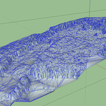
Pre-Development & 3D Mapping
Use our UAVs to collect point clouds, 3D meshes, and GeoTIFFs. We support terrain modeling, yield simulation, and topographic basemaps — optimized for projects up to 10MWp.
Completed Plant Documentation
Capture HD photos and videos for use in investor reporting, O&M audits, or marketing materials. We also offer promotional video editing for your site.
Deliverables:
- High-res visible & infrared imagery
- DXF, DWG, shapefile, GeoTIFF, XYZ point cloud, Infra-red radiometric photo, Visual Photo.
- 3D digital twins for shading and performance analysis
- Volumetric & elevation data
- Customized promo video editing
Industry-Leading Innovation:
Next-Generation 3D Modeling
We integrate near-field UAV data with far-horizon terrain scans to generate the most accurate shading simulations in the solar design industry. Ideal for mountainous and complex terrains.
Why Sunpulse UAV?
- Proven track record with 500+ MW of surveys
- Advanced equipment: 4K cameras, 640×480 FLIR, mix-mode thermal imaging
- Geotagging in IR and visual for efficient hotspot/defect detection.
- Optional Integration with Rotormaps for production of orthomosaic photos in IR and Visual including automated calculation of performance losses, advanced curtailment and yield analytics. 1-click cloud shareable drone survey reports.
Contact Us to book a UAV survey or request a demo
Images